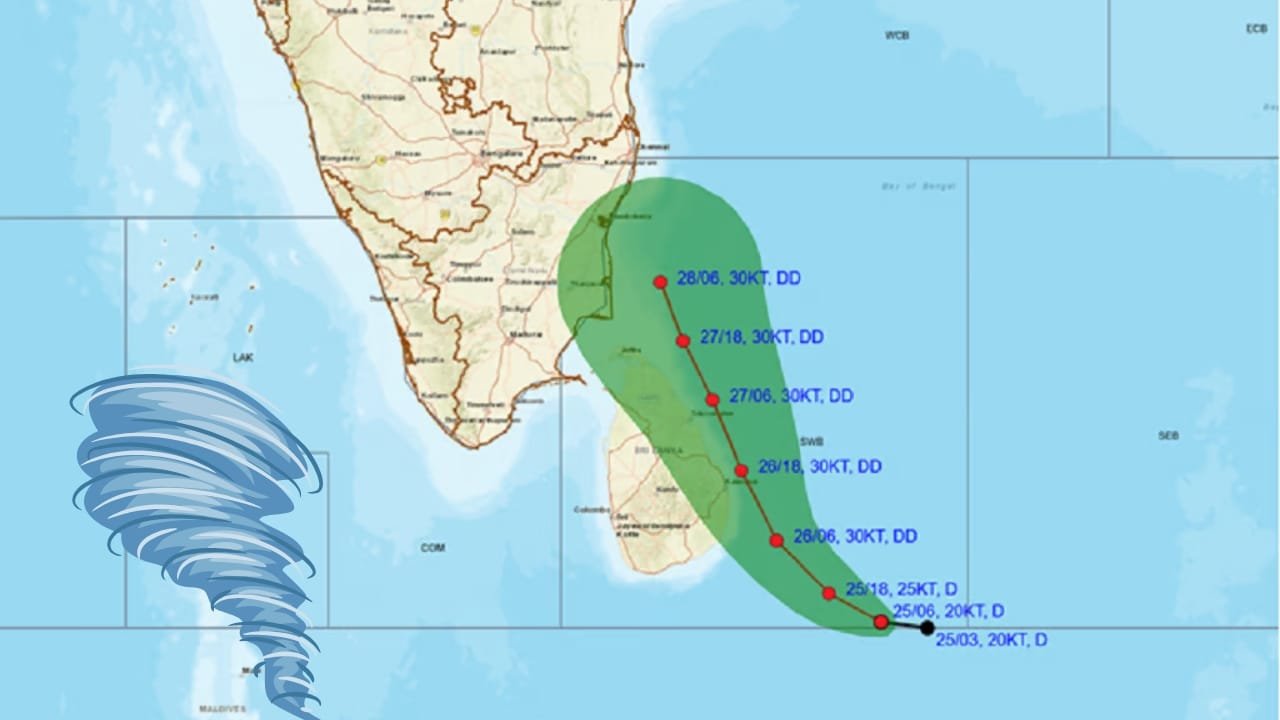
Indian Space Research Organisation (ISRO) has sent its state-of-the-art satellite systems to track Cyclone Fengal, which is expected to hit the Tamil Nadu coast in the near future. ISRO’s EOS-06 and INSAT-3DR satellites have been closely monitoring the growth of the cyclone so that the authorities could come up with crucial information about early warning systems, evacuation, and disaster management. These space-based technologies are indispensable for tracking the cyclone’s behavior and thus providing real-time updates so that risks could be reduced to the minimum in the affected communities.
Understanding ISRO’s Role in Cyclone Monitoring
The growing frequency and intensity of natural disasters can be addressed with the satellite technology of ISRO, which has been a prime contribution to disaster management. On November 23, 2024, ISRO started monitoring Cyclone Fengal with its EOS-06 Scatterometer, from the Oceansat-3 mission, and the INSAT-3DR geostationary satellite. These instruments will provide real-time data on the trajectory and strength of the cyclone so that the authorities have the required information for timely interventions.
Key Satellite Technologies for Cyclone Monitoring
EOS-06 Scatterometer: The Critical Wind Detection Tool
Primarily, the EOS-06 Scatterometer, which has been part of the Oceansat-3 mission, has been one of the primary instruments used for monitoring Cyclone Fengal. This advanced technology played an important role in helping in the detection of patterns related to ocean wind of cyclones. Meteorology experts say that early diagnosis is important for predicting and the intensity of the coming cyclone and its associated effects on coastal areas.
The EOS-06 Scatterometer provides valuable data on wind speeds, giving significant lead time in order to provide the accurate early warnings that allow the local authorities to take precautionary measures ahead of the landfall of the cyclone.
INSAT-3DR: Providing Real-Time Monitoring
Along with the EOS-06 Scatterometer, the INSAT-3DR satellite is operating continuously to provide near real-time data on cyclone development. INSAT-3DR is in geostationary orbit that captures the cyclone intensity and movement and thus providing inputs for more accurate cyclone track prediction by meteorologists. Continuous observations enable timely issuance of early warnings to the public and effective support for disaster response at ground level.
The meteorologists use these real-time updates from INSAT-3DR to create more detailed forecasts of the path of the cyclone so that the authorities can take preventive action, issue advisories, and plan evacuation routes more effectively.

Importance of Space-Based Monitoring in Disaster Management
Integrating space technology into disaster management becomes indispensable in light of growing cases of extreme climatic situations, such as cyclones, caused by global climatic change. One such important tool which enables more effective disaster preparedness and response is through the monitoring systems provided by the Indian Space Research Organisation advanced satellites.
With the collection and analysis of satellite data on an ongoing basis, ISRO ensures that all local and national agencies get timely, accurate information. Such coordination helps in making sure that adequate resources are used to areas most prone to risk. In Cyclone Fengal, ISRO’s satellite data can give a better insight into the cyclone’s behavior so that authorities can make necessary evacuation plans and provide protection measures.
How Satellite Data Enhances Early Detection and Risk Mitigation
Satellite monitoring helps detect cyclones during their early stages. If ISRO’s satellites develop the system, they would give a head start for assessment of the potential threats and necessary action. That early detection is important so that local authorities and people are given adequate time to make safety measures, alerts, and evacuations, if necessary.
Satellite data also helps in risk mitigation by providing accurate predictions on the behavior of the cyclone. This information allows authorities to plan resource distribution, allocate emergency services, and prepare evacuation routes that are aligned with the predicted path of the cyclone. Such coordination minimizes loss of life and property as authorities can make informed decisions on where to deploy rescue teams and emergency supplies.
Coordinated Efforts to Ensure Public Safety
ISRO’s role in cyclone tracking does not operate in isolation. There must be coordination between ISRO, local weather agencies, and government bodies to ensure that the public gets information in a timely and accurate manner. As Cyclone Fengal is headed for Tamil Nadu, the residents are asked to remain vigilant and follow updates from official weather agencies. The coordinated efforts of satellite technology and ground-based resources make it a potent combination that greatly enhances the effectiveness of disaster response.
In Tamil Nadu, local authorities are relying on ISRO data to inform their evacuation strategies and determine the best course of action for mitigating risks to human life and infrastructure. As conditions continue to change, these authorities will use satellite data to track changes in intensity of the cyclone in order to adjust their responses in real-time.
Also Read: Lithium Mining’s Potential Environmental Impact on Water Quality: Key Findings from Recent Study
The Future of Satellite Monitoring for Disaster Management
Satellite technology applied in the surveillance of natural disasters is constantly getting developed, and this advancement, in particular, comes along with ISRO, for which the significance is in the role the coming years will give them regarding controlling extreme weather changes brought forward by climate change. Beyond tracking cyclones, its satellites are an integral resource for monitoring other types of natural disasters – floods, droughts, and wild fires.
Looking ahead, artificial intelligence and machine learning integration into data processing from satellites will even further enhance the ability of predicting and mitigating impact from natural disasters. So, with the help of cutting-edge technologies, ISRO will be helping communities in the country and around the globe to be safe.
Conclusion
This deployment of ISRO’s EOS-06 and INSAT-3DR satellites to monitor Cyclone Fengal testifies to the critical role space-based technologies play in disaster management. Advanced systems, such as these, provide real-time data on the behavior of the cyclone, enabling authorities to issue timely warnings, enhance preparedness, and protect vulnerable populations. As extreme weather events keep increasing in frequency, the satellite monitoring capabilities of ISRO will remain a corner stone of India’s disaster response efforts, saving lives and minimizing risks.

